Hurricane watch in effect for Barbados - Barbados Today
A hurricane watch is in effect for Barbados as Tropical Storm Beryl continues to strengthen and become a hurricane before reaching the island late Sunday night.
On the current projected track, the center of Beryl is expected to pass 45 km (26 miles) south of Barbados.
The island is expected to feel the impacts associated with this system as early as late Sunday night.
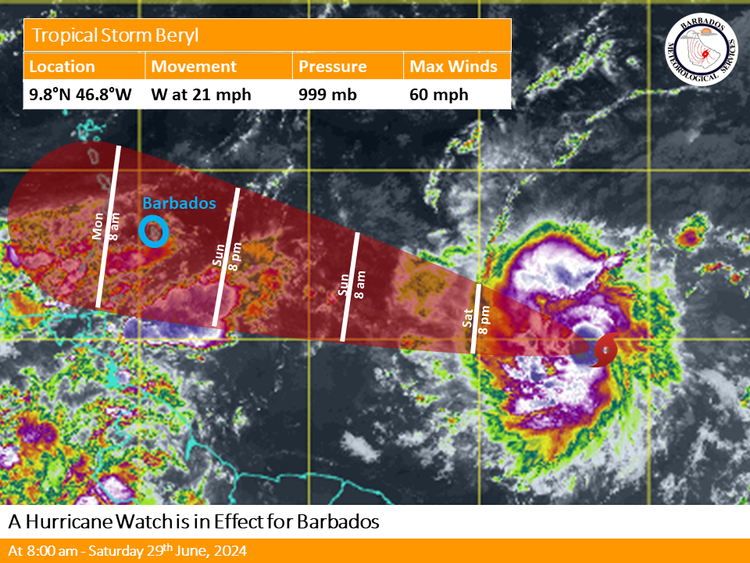
At 8 a.m. Saturday, the storm was located near 9.8w 46.8w or about 1570km (975 miles) east-southeast of Barbados.
Maximum sustained winds are 60 mph (95 km/h). Present movement is towards the west at 21 mph (33 km/h). The minimum central pressure is 999mb.
Possible Impacts
During the passage of Beryl strong winds can cause damage to homes and properties. Additionally, flash flooding is likely across the island especially in flood-prone areas and severe thunderstorm activity may cause multiple interruptions to power utilities and services.
Marine conditions will be hazardous ahead of and during the passage of Beryl and a small craft and high surf warning are currently in effect for above-normal sea swells which is expected to deteriorate from Sunday night.
What you should do
The public is encouraged to follow the advice provided by the Department of Emergency Management and other local officials in addition to monitoring the BMS, DEM and GIS websites, their respective social media pages, and the local media networks for further information on Beryl.


